Satellite IoT Solutions
Real Time Data, Deep Learning Algorithms And Actionable Insights
A digital precision agriculture tool, Satellite IoT Solution equips you, from space, with the ground-truth data you need to make timely, informed decisions.
It utilises the latest satellite data, processed and analysed with widely-used and custom algorithms, such as field contours, tile-based map rendering, VI dynamics, cloud/shadow mapping and change detection among others. Monitor multiple fields at once while tracking the VI change in correlation with the weather, growth stages, crop rotation and other data. Get notified via email and make precision-driven decisions, thus increasing yields and revenue.
Farm more efficiently, profitably and sustainably with continuous field coverage
Gain agronomic insight through field-level detail
Monitor and analyse field and crop health from pre-season to harvest
Field Monitoring
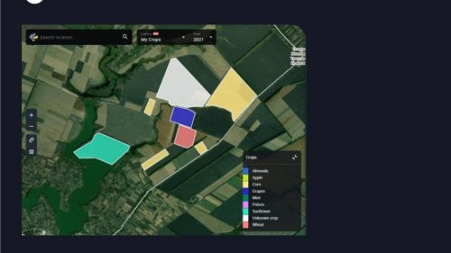
Field Monitoring
Have a bird’s-eye view of your fields. Get notified about both regular and abnormal changes in the state of your crops throughout the season, based on the automatic VI calculations.
Vegetation Indices
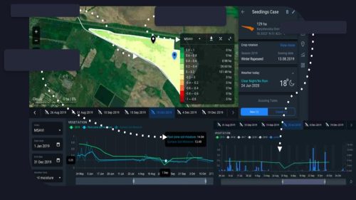
Benefit from the algorithm that identifies vegetation density levels on the field throughout the season. Use different vegetation indices (NDVI, NDRE, MSAVI, ReCl) at different growth stages to get the most accurate information about the health of the crops.

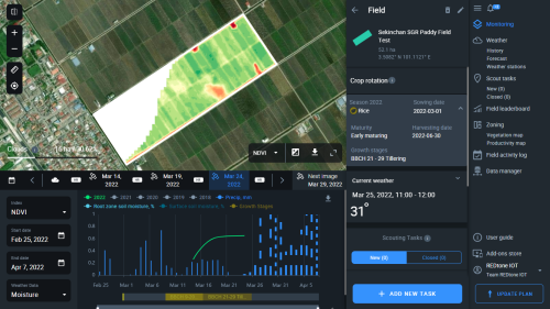
Water Stress Detection

Prevent harvest loss by letting the app detect and analyze abnormal precipitation and critical sudden NDVI change. Take necessary precautions in a timely manner.
Growth Stages
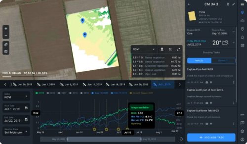
Track growth stages of your crops on the chart, according to the international BBCH-scale. Check the correlations between growth stages and other data on the chart (vegetation indices, temperatures, precipitation, among others) and make appropriate field treatment decisions, thus lowering costs and increasing yields.

Improved Cloud Mask

Improved Cloud Mask
Let the system automatically detect clouds over the fields.
Crop Rotation

Crop rotation data for each field, including sowing dates and season, is conveniently displayed, along with the map, weather data, and vegetation indices, in one screen. Add crops, their sowing dates, seasons, and access this data anytime anywhere.

Who Should Use This?
Smallholder Farmers
Greater insights into the health of their crop, including historical data such as weather, soil conditions, yield, etc which can be correlated to actual harvested yield.
Commercial Growers
Greater insights into the health of their plantations, including historical data such as weather, soil conditions, yield, etc which can be correlated to actual harvested yield.
Government Agencies
For monitoring large swaths of agriculture land to monitor the effectiveness of crop inputs, crop yields, bug infestations, water shortages, etc. Increased efficiencies in subsidy use & accountability.

Financial Services Providers (Loans & Insurance)
Ability to monitor loan recipients’ farm health, measure potential yields, ascertain historical yields for risk assessment for both loan approval as well as crop insurance services
News
REDtone in deal to modernise agriculture, data utilisation
KUALA LUMPUR: Redtone Digital Bhd is partnering EOS Data Analytics to offer satellite-based remote sensing solution to modernise the country’s agriculture and enhance data utilisation and artificial intelligence in the sector.
Source: TheSun
#TECH: Satellite-based remote sensing strengthens Redtone’s smart farming solution
KUALA LUMPUR: Redtone Digital Berhad, an integrated telecommunications and digital infrastructure services provider announced a partnership with EOS Data Analytics (EOSDA), a global provider of AI-powered satellite imagery analytics to modernise Malaysian agriculture and enhance the utilisation of data and AI in the sector.
Source: New Straits Times
REDtone partners with EOS Data Analytics to offer satellite-based remote sensing solution
REDtone Digital Bhd, an integrated telecommunications and digital infrastructure services provider announced a partnership with EOS Data Analytics (EOSDA), a global provider of AI-powered satellite imagery analytics.
Source: Business Today
Kindly Contact Us to Request Demo
DOWNLOAD OUR PRODUCT BROCHURE
Need help finding solutions?
Get In Touch

Sales Enquiry

Sales Enquiry
Sales Hotline
1800 87 7770
+603 8084 8070
(if you are abroad)
Email Us

Customer Care

Customer Care
Support Toll Free
1800 87 7790
+603 8084 8910
(if you are abroad)


